Totally could have happened in our period...
As we might have expected, I guess, the pressures of teaching have prevented much going on here since our last blog post, but I wanted to close off the year with some sort of small present for the world, to which I can attach our best wishes for all our readers. So here is a story of modern frontiers that I found, and I'll try and draw some interest out of it for non-modernists.

Dr Nathalie Raunet
Back at the sort of time when your humble blogger and Emma Cavell came up with the initial idea for this project, one of the other people I spoke to about it was a then-colleague by the name of Nathalie Raunet, now Dr Nathalie Raunet and based at the Freie Universität Berlin at their Exzellenzkluster "Contestations of the Liberal Script (SCRIPTS)", who do just the kind of deconstruction of international-law statism in the face of lived reality which I think our project can also offer. Dr Raunet was interested in what we were doing because she works on modern West Africa, whose frontiers and boundaries were essentially drawn on a map with a ruler by Western colonial governments and really make little or no lived sense on the ground, causing some very peculiar phenomena to work out around them. I also thought this was pretty interesting, so when reactivating the project most recently, I looked Dr Raunet up and found an interesting article she published in 2019, called 'Elections and Borderlands in Ghana'.1 The crux of this article is that, because of compatible dual-citizenship laws which also afford citizenship by descent, there are or were then 76,000 people on Ghana's electoral register who are also registered to vote, and live, in neighbouring Togo. One of the main political parties in Ghana argues, or was then arguing, that these transnational voters largely favour their opposition, and so was then attempting to get their non-resident voter status anulled. That is the article's actual topic, and if it sounds interesting I very much recommend you read it, but I confess, I was more into it for the little bites of frontier weirdness, and none more so than this:
Some parts of the Togolese borderland region have few road connections to the rest of Togo and it has turned towards Ghana where rural areas are better connected to the rest of the Ghanaian road network. The people of the border town Badou in Togo even decided to raise a Ghanaian flag and claimed that the town was Ghanaian until the Togolese government did something to connect them to the rest of the Togolese hinterland.2
I haven't been able to give this post the time to find out how long this situation lasted, or how it was resolved, although for what it's worth Dr Raunet's reference suggests, firstly, that this was not the first time this had been done and secondly, and perhaps more surreally, that this time (in 2013) it was sparked by the relegation of Badou's football club to the Togolese second division, which was perceived as a conspiracy against the town, supposedly led by a highly-placed policeman who supported the team they had recently almost beaten to the top of the first division.3 Now, raising that flag was a potentially dangerous action to take, as the Togolese government has in the past been fairly ugly in its dealings with opposition; but it seems that so far away from its centre – about 250 km from the capital on a largely unasphalted national highway, no rail option – local politics can proceed with more independence, including negotiation by local chiefs with the central regime over exactly what control of a voting bloc can buy their communities.4 And that independence can encompass at least the pretence, it seems, of secession, although across the border from it, the matching Ghanaian province of West Togoland has a more prolonged attempt to get to the other side of the border going on.5
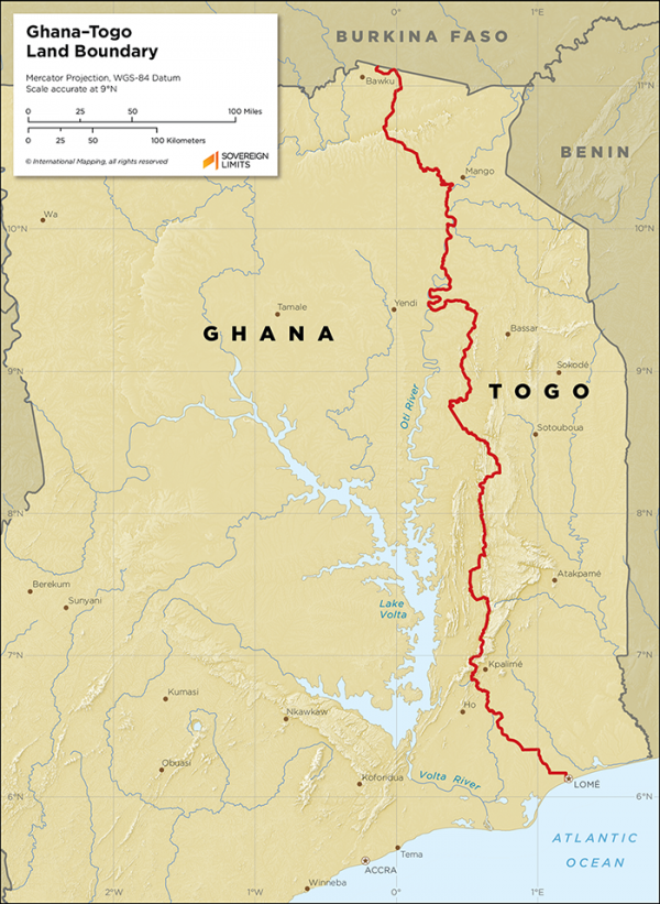
Map of the Ghana-Togo land border, from Ghana-Togo
, Sovereign Limits, 16 January 2023 <https://sovereignlimits.com/boundaries/ghana-togo-land>
It is pretty obvious, therefore, that though people are putting it to work in their interests here, the Ghana-Togo border is what one international-development study report I read calls a 'boundary with issues'.6 On both sides, there are communities who feel that their primary identity is with a group on the other side; there are, as Dr Raunet shows, marriage and other negotiations going on across the line all the time; and when one sees the lines on a map, as above, it is very clear that this is because they follow conveniently obvious geographical lines such as rivers, not because they made sense of local circumstances. But, given that I argue that medieval societies can inform modern frontier thinking because they did not use such linear boundary structures, what do the Middle Ages have to add to the observation that state-drawn boundaries aren't always that well-drawn?7

Roman walls and church spires in Zaragoza, Spain, image by Liberaler Humanist, licensed under CC BY-SA 3.0, via Wikimedia Commons
Well, a paper I gave at the 2016 International Medieval Congress at the University of Leeds does actually have some similar factors going on. Here the operative agency is not a football team's following, but a family of convert warlords in the dar al-Islam of medieval Iberia, but bear with me. The family in question were called the Banū Qāsī, the 'sons of Cassius', and, at least by the 840s CE, claimed to be descendants of a Count Cassius who, when the Muslims conquered the Visigothic kingdom in 711-718 CE, is supposed to have travelled eastwards to receive conversion to Islam from the caliph himself, rather than any of the local authorities.8 By the 840s, they (in the person of their most famous scion, Mūsā ibn Mūsā) were using claims like these, along with the fact that because of factors now hard for us to assess they were one of only a very few families of influence along the north-western border of al-Andalus (that is, Muslim Iberia) who could manage to govern that march, to get themselves emplaced as lords of not just their apparent family centre at Arnedo, but usually the city of Tudela, which now celebrates Mūsā as one of its greatest children, and ideally the march's capital at Zaragoza as well. They did this by a peculiar cocktail of local action against rivals, appeals to the Emir of Córdoba, local top ruler, defence against and submission to the emir's reprisals when they went too far, and diplomacy across the border, out of which Jesús Lorenzo Jiménez has made an excellent book and which I therefore can't summarise here in a sentence.9 However, it's with the diplomacy across the border that the parallel I'd like to draw starts.
.JPG)
Statue of "Muza Rey del Ebro", that is, Mūsā ibn Mūsā Ibn Qāsī, in Tudela, image by Arenillas, own work [Public domain], via Wikimedia Commons.
What was across the border, most immediately, was the Basque principality of Pamplona. Pamplona's status with respect to the emirate of Córdoba was somewhat ambivalent. In early Islamic political thinking there were really only two categories of space, the dar al-Islam (domain of Islam, where Islamic rule was established) and the dar al-harb (the domain of war, where it still had to be), but there were two important interspace categories as well. One of these was the zone between the two other, the thaghr, which we usually translate as 'frontier' but which more literally means 'passage'. These could be very large; the one which the Banū Qāsī occupied, the sharq al-Andalus, 'edge of Andalus', Zaragoza's dependent provinces, ran from the coast down there to Pamplona and was many miles across. Lordship of it put one in control of a significant, single-figure fraction of Andalusī territory.10
The other interspace category, however, was the dar al-'ahd, 'the domain of the pact', which denoted territory which had submitted to Islam on terms, but which by this means had avoided coming under direct Islamic government. In the eighth century, it now seems clear, Pamplona had either been directly conquered by Islam or had come under such a pact; a substantial Islamic cemetery in Pamplona some of whose occupants carbon-dated out to this period seem to confirm that there was for a while at least an Islamic population, perhaps a garrison, there.11 In the late eighth or early ninth century, however, the Franks from the north under Charlemagne and his son and successor Louis the Pious took over Pamplona fairly aggressively. The Frankish sources say nothing of it being Islamic territory, but it was still very resistant to this, beginning with the famous Battle of Roncesvalles which would, rather later, give the world the famous epic Song of Roland, but ending with a successful rebellion in the 820s which took both Pamplona and Aragón definitively out of Frankish control.12
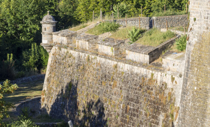
Pamplona is now somewhat better defended than that, although thankfully with less cause. This image of the city walls from Euskoguide, linked through
At that point, then, it is not very clear whose territory Pamplona was (other than the Basques'). Two different imperial régimes claimed it, but neither could exercise much direct influence there without sending an army, and the Carolingian dynasty of the Franks evidently decided no longer to do that. That did not, however, return it to effective Muslim dominion. Yet it's clear from our sources on the Banū Qāsī that it was still considered to be under the pact, and it's in those sources because it was the Banū Qāsī who made this happen, because Mūsā ibn Mūsā's father (Mūsā ibn Fortūn) had married into the Pamplona ruling family.13 As long, therefore, as the Córdoba régime could count on the Banū Qāsī they also still had Pamplona in some kind of relationship, and the border of notional Islamic territory lay in the Pyrenees. At times when they could not count on the mercurial warlords, that border lay south of Zaragoza. The allegiance of the Banū Qāsī could, with a single letter of defiance or submission to the Emir or his functionaries, throw the edge of Islamic territory 80‒100 km in either direction and move four or five cities in or out of the thaghr from or to the dar al-harb.14
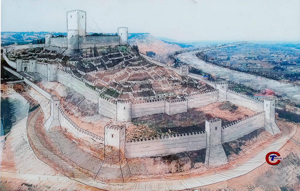
Reconstruction drawing of the (later) medieval walls and Alcazar of Tudela, image by Papix - Trabajo propio, licensed under CC BY-SA 4.0, via Wikimedia Commons
Of course, nothing actually moved when this happened. The cities stayed in the same place and so did their governors, unless they were politically imperilled by the new order; some troops perhaps trooped from north to south or vice versa depending on where the most serious threat to the Banū Qāsī position now lay; but in general these shifts of allegiance can have made very little difference to day-to-day life within the sharq al-Andalus, where inter-aristocratic violence was always a possibility anyway, or to entering or leaving it unless one came with an army. It probably didn't even make much difference to the flow of tax revenue, since usually thughur (the plural of thagr) were allowed to keep their tax revenue to run local defence. In this respect, the border did not 'happen to' people here very hard. (Likewise, raising that Ghanaian flag over Badou didn't actually move the town or any people or, I guess, even make Ghana any richer for the while it lasted.) But in another respect the border determined everything. The Banū Qāsī's position was so powerful because they were on it; they could bring not just their own province but the one next-door into a notional obedience that extended Cordoban dominion to almost its historic limits in the Pyrenees, or cut it sharply back; they could allow the emir to show that he was able to defend his frontiers (through the swords of others) or make him admit that he very obviously wasn't; and because of the marriage link to Pamplona they could do this better than any other such local family of warlords. So for most of a century they were the emir's necessary clients in the area if the emir wanted, yes, control of any kind, but also the prestige of ruling what his ancestors had ruled and safeguarding Muslims therein.
The timespan I mentioned there, however, obviously tells us that this didn't last forever.15 Things seem to have become unbalanced towards the end of the ninth century, when several things happened. Firstly, in 875, after a lightning coup in 871 which placed the family suddenly and briefly in charge of almost every city in the march, the family lost control of Zaragoza for the last time. After some back and forth, and despite an eighteen-year siege by three generations of the Banū Qāsī (!), the capital of the march now became the seat of the Banū Tujīb, the kingroup who would, ultimately replace them. This was part of the second thing that happened, a determined attempt by the emirs consistently to promote another lineage in the area so that they could in fact vie with the Banū Qāsī. And the third thing, usually explained by dynastic change in what was becoming Navarra, is that in the years after 900 the Banū Qāsī relationship with Pamplona, now generations old, fell apart and they became targets for each others' raiding. With this, of course, the unique advantage the family had held, as well as its contentious but numerous membership being thinned out by the consequences of these failures, crumbled away. They were now no better positioned than the Banū Tujīb, who had the advantage of central support that the Banū Qāsī could no longer access. And, with Pamplona definitively lost to control, it transpired that the future Caliph, Emir 'Abd al-Raḥmān III, was prepared to admit that the frontier now lay south of Pamplona if he could nonetheless guarantee that it still lay north of Zaragoza and Tudela.16 The last of the Banū Qāsī was killed as a fugitive guest of the Count of Christian Pallars, by his host, in 929.
So, from all this I draw two lessons, one for then and one for now. The one for then is that even if the sudden 100-km switches of the frontier back and forth probably changed little on the ground, it determined a lot about politics; the ability to do that to the frontier made the Banū Qāsī powerful because the location of this reasonably notional line of power mattered enough to the people who made them powerful; once they were maximally powerful their location there placed them beyond immediate control, too; but because the state was ultimately willing to draw the border in a different place by a series of means, they found themselves within it and within reach of power again. They, and therefore their opponents and their men, fought and died over where that line should be, wrecking orchards, crops and harvests on their way. Even though there plainly was community over and through this border space, political membership of larger organisations made the line realler than its absence. This could obviously also apply elsewhere.
But the point for the now is more optimistic. The narrative arc of the Banū Qāsī is from the establishment of a community, through the imposition of a frontier, then the local exploitation of that frontier for political ends and finally to the imposition of that frontier and the destruction of the community links across it (albeit probably never very thoroughly). But I don't know that those parts of the sequence have to go in that order. The Ghana-Togo example suggests otherwise: there we have the existence of a community (I don't know its history)17, the imposition of a frontier and the imperfect destruction of links across it, the local exploitation of that frontier for political ends and next, who knows, but possibly the negotiation of a recognisable community again – or, admittedly, its probably violent secession. Again, where the line is makes a difference, but it isn't necessarily the difference anyone expected who put it there; the recognition of that line by outside agencies of power places special restrictions upon, but also opens up special opportunities to, those living there, whether it be negotiating better roads or schools by threatening secession or simply voting in two countries. I think I do understand this better for having studied people taking cunning advantage of frontier situations based around notional but invisible lines on mental or physical maps in other contexts. Dr Raunet also doubtless understands it much better than I do for having spent time there talking to people whom the situation directly affects, whereas I am being the archetypal armchair anthropologist without even the pretence of anthropological training! But I can still offer extra models, because these situations do in fact relate to each other. And that's what I'm out to try and show, really.
1. Nathalie Raunet Robert-Nicoud, Elections and Borderlands in Ghana
, African Affairs, 118.473 (2019), 672–91 <https://doi.org/10.1093/afraf/adz002>.
2. Ibid., p. 687.
3. Thi, Togo : Grogne de la population de Badou, après Dapaong et Niamtougou. A qui le tour?
, 27avril.com, 18 mai 2013 <https://www.27avril.com/blog/culture-societe/societe/togo-grogne-de-la-population-de-badou>.
4. Raunet, Elections and Borderlands
, 688–90; see also Nathalie Raunet, Chiefs, Migrants and the State: Mobility in the Ghana-Togo Borderlands
, Working Paper WP-16-131 (Oxford: Centre on Migration, Policy and Society, University of Oxford, 2016) <https://www.compas.ox.ac.uk/2016/chiefs-migrants-and-the-state-mobility-in-the-ghana-togo-borderlands/>.
5. Samuel Adu-Gyamfi, Sebastian Angzoorokuu, Edward Brenya, Dominic Degraft Arthur and John Mensah Letsu, Rethinking the Influence of Colonialism on Secession in Africa: The Case of the Western Togoland Independence Movement in Ghana
, Australasian Review of African Studies, 42.2 (2021), 4–25 <https://doi.org/10.22160/22035184/ARAS-42-2/4-25>.
6. Annette Weber, Boundaries with Issues: Soft Border Management as a Solution?
(Berlin: Friedrich-Ebert-Stiftung, January 2012) <http://library.fes.de/pdf-files/iez/08869.pdf>, of which, I admit, the title is the only part I'd recommend.
7. I should say, not least because it is disputed, that medieval people were perfectly capable of establishing a linear frontier if they wanted; we have several treaty agreements, as well as thousands of land disputes, that make that perfectly clear. See for example Florin Curta, Linear Frontiers in the 9th Century: Bulgaria and Wessex
, Quaestiones Medii Aevi Novae, Frontiers and Borderlands, 16 (2011), 15–32, for two of the treaty lines, and Jeffrey A. Bowman, Shifting Landmarks: Property, Proof, and Dispute in Catalonia around the Year 1000 (Ithaca, NY: Cornell University Press, 2004) for some of the land disputes. Lots of those boundaries must also have cut through communities or mutual spaces, though at least the so-called Treaty of Alfred and Guthrum, one of those dealt with by Curta in that article (though see also David N. Dumville, The Treaty of Alfred and Guthrum
, in Wessex and England from Alfred to Edgar: Six Essays on Political, Cultural and Ecclesiastical Revival, by David N. Dumville (Woodbridge: Boydell & Brewer, 1992), pp. 1–27, for why I say "so-called") dealt with crossing as a normal expectation too. But these boundaries were not meant to set up the same structures as our modern ones, I think. Probably a different post!
8. On their disputed origins see Jesús Lorenzo Jiménez, Algunas consideraciones acerca del conde Casio
, Studia Historica: Historia Medieval, 27 (2009), 173–80 <https://dialnet.unirioja.es/servlet/articulo?codigo=3177350&info=resumen>; cf. Maribel Fierro, El conde Casio, los Banu Qasi y los linajes godos en al-Andalus
, ibid., 181–89 <http://www.redalyc.org/pdf/3675/367539050011.pdf>, and Eduardo Manzano, A vueltas con el Conde Casio
, ibid., 31 (2013), 255–66 <http://revistas.usal.es/index.php/Studia_H_Historia_Medieval/article/view/11742>.
9. Jesús Lorenzo Jiménez, La dawla de los Banū Qasī: origen, auge y caída de una dinastía muladí en la frontera superior de al-Andalus, Estudios Árabes e Islámicos: Monografías, 17 (Madrid: Consejo Superior de Investigaciones Científicas, 2010).
10. See Eduardo Manzano Moreno, La frontera de al-Andalus en época de los Omeyas, Biblioteca de historia, 9 (Madrid: Consejo Superior de Investigaciones Científicas, 1991), and for an accessible account of the concepts in English Manzano, Christian-Muslim Frontier in al-Andalus: Idea and Reality
, in Arab Influence upon Medieval Europe, ed. by Dionisius Agius and Richard Hitchcock, Folia Scholastica Mediterranea, 18 (Reading, IL: Ithaca, 1994), pp. 83–96.
11. María Paz De Miguel Ibáñez, Gentes del Islam: Ritual funerario e historias de vida en la maqbara de Pamplona
, Studia Historica: Historia Medieval, 38.1 (2020), 7–28 <https://doi.org/10.14201/shhme2020381728>.
12. For the real frontier politics see Roger Collins, Early Medieval Spain: Unity in Diversity, 400 - 1000, New Studies in Medieval History, 2nd ed (Basingstoke: Macmillan, 1995), pp. 250–63, or Julia M. H. Smith,
, in The New Cambridge Medieval History Volume II: c. 700-c. 900, ed. by Rosamond McKitterick (Cambridge: Cambridge University Press, 1995), pp. 169–89 <https://doi.org/10.1017/CHOL9780521362924.009>; on the Song of Roland, which is published in English as The Song of Roland, trans. Glynn Burgess, Penguin Classics F26 (London: Penguin Books, 1990), or more immediately as The Song of Roland, trans. by Jessie Crosland, Old French (Cambridge, Ont.: In parentheses, 1999) <https://www.yorku.ca/inpar/roland_crosland.pdf>, see to start with Susan P. Millinger, Fines Imperii
: The MarchesEpic Values: The Song of Roland
, in The Middle Ages in Texts and Texture: Reflections on Medieval Sources, ed. by Jason Glenn (Toronto: University of Toronto Press, 2011), pp. 141–52, and Fuat Boyacioğlu and Mustafa Zenginbaşa, The Expedition Of French King Charlemagne In Spain In 778, Historical Sources And Anachronic Reflections On The Song Of Roland
, ed. by Jerry Willis and Ana Donaldson, Turkish Online Journal of Educational Technology, INTE 2015, 14, Special Issue (2015), 639–43 <http://www.tojet.net/special/2015_9_1.pdf>, the latter just for a comparison of the text with real events.
13. See Roger Collins, The Basques, The Peoples of Europe, 2nd ed (Oxford: Basil Blackwell, 1990), pp. 140–43, or now Juan José Larrea and Jesús Lorenzo, Barbarians of Dâr al-Islâm: The Upper March of al-Andalus and the Pyrenees in the Eighth and Ninth Centuries
, in La Transgiordania nei secoli XII-XIII e le frontiere
del Mediterraneo medievale. Trans-Jordan in the 12th and 13th Centuries and the Frontiers
of the Medieval Mediterranean, ed. by Guido Vannini and Michele Nucciotti, British Archaeological Reports (International Series), 2386 (Oxford: Archaeopress, 2012), pp. 277–88 <https://www.academia.edu/2943005/Barbarians_of_Dar_al-Islam_the_Upper_March_of_al-Andalus_and_the_Western_Pyrenees_in_the_8th_and_9th_centuries_J.J._Larrea_and_J._Lorenzo_>.
14. This was the basic point of my 2016 paper, for which a full citation would be Jonathan Jarrett, Heartland and Frontier from the Perspective of the Banū Qasī, 842–907
, unpublished conference paper presented at the International Medieval Congress, University of Leeds, 7 July 2016.
15. Covered in Lorenzo, La dawla de los Banū Qasī, pp. 275–340.
16. On whom a very good introduction is Maribel Fierro, ʿAbd Al-Rahman III: The First Cordoban Caliph, Makers of the Muslim World (Oxford: Oneworld, 2005).
17. Though in researching this post I have found out about R. Bagulo Bening, The Ghana-Togo Boundary, 1914-1982
, Africa Spectrum, 18.2 (1983), 191–209 <https://www.jstor.org/stable/40174115>, and Paul Nugent, Boundaries, Communities and State-Making in West Africa: The Centrality of the Margins, African Studies (Cambridge: Cambridge University Press, 2019) <https://doi.org/10.1017/9781139105828>, which look like good places to find out more.